
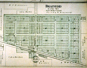
This updated, 1905 town plat map reveals a Brainerd chopped off below the railroad line, after the Kansas legislature deeded the land south of the tracks back to farmland. The depot still occupies the southwestern corner of Broadway and the tracks, across the street from the stockyards (where the remains of the Brainerd grain elevator now stand).
To see a larger version of this map, you can click here and launch yet another browser window, from which you can print out a copy for your perusal while navigating this site.
|
|